Map: Regions of Scotland
Use the basic Highland Tour as your starting point
Defining boundaries can be difficult. Local government reorganisation has in the past created then abolished County and Regional boundaries. Not all boundaries are political, many are cultural, influenced by invasion, geography and history. Postal boundaries are based on the old county names.
For the purposes of organising tours I have arranged the map into areas that we ourselves use when referring to Scotland. Even that is fluid; for instance, Argyllshire (county), Argyll and Bute (political) can be included in the Highlands or Lowlands.
All tours start with a blank map and your imagination. Build a route based on your interests. Decide what you would like to see and do and how long you've got.
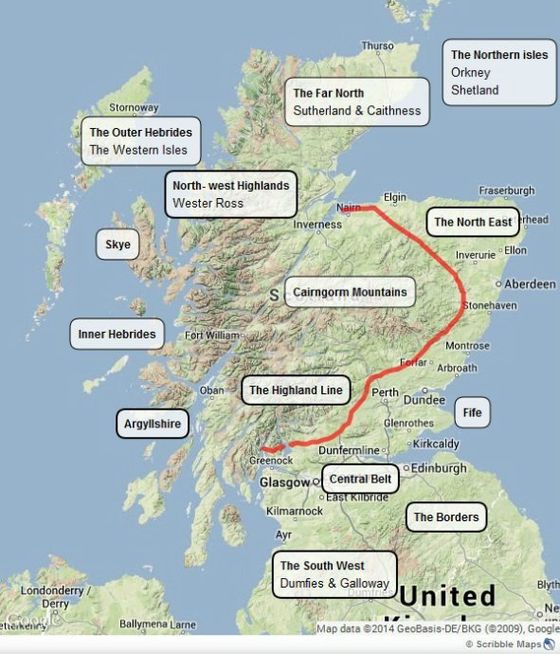
The Highlands
loosely anything above and west of the highland line
Outer Hebrides or Western Isles
the outer chain of islands from Barra to Lewis
Isle of Skye (part of the Inner Hebrides, islands off the west coast down to Islay)
The area around Fort William is referrred to as the West Highlands
The (Far) North: (Wester Ross and parts of Sutherland are often referred to as the North-west Highlands)
Wester Ross
Cromarty and the Black Isle
Sutherland and Caithness
Orkney together with the Shetland Isles are collectively referred to as The Northern Isles
The North East:
The North East
Aberdeenshire, Banff and Buchan
Central and South Scotland: Lowlands or Central Belt includes
Edinburgh and Glasgow
Central Region
The Kingdom of Fife
Scottish Borders
Argyll and Bute includes Kintyre
The South West includes the Ayrshire Coast